Free phone-based tracker and friend locator
Feb 2008 NEWS: Now has a radar that shows other users (who need perform NO registration) in the vicinity.
What this is
A tracking application that runs on your phone, talks to a bluetooth GPS (NOT inbuilt ones) and
enables you or other authorised people to see where you are on a
Google Map. The markers on the map are clickable and display time,
course and heading. Before showing you how it looks see also my Google Maps based GPX route creator. Back to the tracker. Here's how it looks.
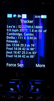
Here's the application on my phone, showing the UK gazetteer and
distance and bearing to friends with a similar setup.
(Note that the map on the right doesn't correspond to this data and the friends are made up (sniff) though the system does work.)
|
|
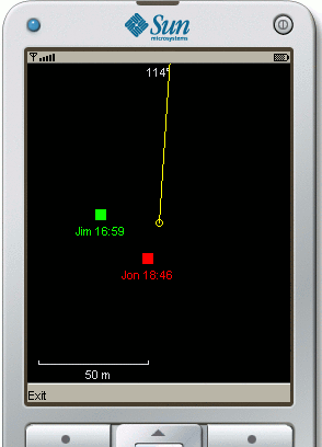
Loved ones or people with nothing better to do could meanwhile be sitting at home watching yon on the map.
|
And now for something barely off the testbed though working fairly well.
One of the many reasons for this project is for cycling and the
connection it has had with tracking systems for me over the last few
years. The next major unimplemented feature will direct you to
friend(s) with a similar setup.
About the cost. If you want to use it for cycling or similar that's
great. Tell me what you're up to and if you'd really really like it to
work on such-and-such a date when you do your end-to-end and I'll try
harder not to break it then.
Otherwise you get what you pay for until such time as I work out the
details of the commerical variant.
What you need
-
A modernish mobile phone with bluetooth, working GPRS, Java MIDP
2.0 and JSR-82. JSR-82 gives Java applications the ability to use
bluetooth and is not a given. Consult the MIDP and JSR-82
columns here. At
the time of writing it works well on a Sony Ericsson K810i and a Nokia
6300. It has worked on a Nokia 6230 but later its GPRS stopped working
for no good reason. The 6230 is prone to "Application Error" when
installing both this application and other known-good ones and is
generally non-deterministic in the Java department.
If you have some sort of browser on your phone and it works then the
GPRS thing is probably ok.
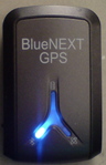
- A bluetooth GPS. Those local to me in
Concrete
Cambridgeshire Silicon Fen can borrow my Bluenext
GPS briefly for testing purposes. My Ł25 Bluenext device
seems to work well stuffed in my saddle bag mostly obscured my
not-so-compact rear end.
-
Awarenes that the GPRS communications will cost you. Sending a fix and
returning "friend" data is only of the order of a hundred bytes so
should be much less than a penny but it's down to your operator. If in
doubt after a short test wait until you can check your itemised bill
or drop in credit. Note that in the case of O2 (UK) although their
data charges are high (though under pressure to plummet with the
arrival of the iPhone), these transmissions seem to be under the radar
and cost the square root of bugger all so that's nice. I have had the
application work with both Orange and Virgin/T-Mobile PAYG SIMs. (I'm
not quite sure of the relationship but noticed Virgin's offer for a
free Ł5 loaded SIM, took it and found myself on the T-Mobile network
with it.) You do with Orange at least have to ask them to
"data enable" your account if not already done.
-
Sense not to look at your phone while driving/riding. I'd like to add
some simple voice output at some stage with this in mind.
How to install
Bluetooth pairing
Pairing may or may not be a necessary step but is definitely a good
idea if nothing else to check that the bluetooth in both devices
works. Follow your phone's and GPS's instructions to pair them. For
the impatient the instructions will go something like this. Switch the
GPS on along with Bluetooth on your phone. Find the list of bluetooth
devices on your phone, select "Add device", type in the PIN (likely to
be 0000) and you're done.
Install the application
It can be installed in one of three ways.
The first method involves typing a URL into your phone's browser to
download it. This will cost you a few pence. The (case sensitive) URL is
http://jschneider.net/JaTrack.jad
The second method avoids pushing as many buttons on your phone but
still might be more difficult. If you are confident transferring files
(could be via Bluetooth, Infrared or the phone's USB lead) then fetch
the JAR file below and transfer it to somewhere appropriate or do
whatever is appropriate for your phone. For Nokia users that probably
means using the Nokia data suite.
This is version 0.93 released on Tuesday 27th May 2008 and features
most recently a few more Radar screen scales (for somebody who wants to
take it to a festival) and a keyboard lock.
http://jschneider.net/JaTrack.jar
The third way is to beam it from another phone by
bluetooth or infrared. What you beam is the uninstalled jar file. The
Nokia 6230 is able to receive the file (by infrared but not bluetooth)
but then knows not how to make use of it.
Whichever way you should get prompted to install the application and
may be warned that it is from an untrusted source. That's because I
haven't paid for a certificate to sign the thing. This same
tightfistnedness means that on some or all phones you can't avoid
being asked per invocation whether bluetooth and network access are allowed.
How the GPS is found
If the list of known, either from pairing or a device search depending
on the phone, bluetooth devices on your phone now includes exactly one
device with the text GPS in its name then that will be chosen. For
most people that should be the end of it. Otherwise you may get a list
pop up to choose the device. All being well you won't be asked
again. Should you get it wrong or change your GPS module select
"Device". Once the application is settled it will not accidentally
connect to another GPS even of the same type unless tha manufacturer
naughtily duplicate MAC addresses.
How do I know it is working ? What if it isn't ?
Understand what the flashing lights on your Bluetooth module really
mean which might not correspond to the documentation.
There are two things likely to go wrong. Firstly the Bluetooth
communications. If this is the case "No GPS" is displayed.
Secondly the GPS working but not giving a fix. "No Fix" will be
displayed. When there is a fix (lat/long and other stuff displayed)
the application will then (and at intervals of 5 minutes or 1 nm) try
to send it to the server. The first time the phone is likely to ask
your permission. Depending on the phone you might see a globe for a
few seconds when these transmissions happen.
When there is communication over GPRS with my server the application
emits a high tone. A lower tone a second or so later means it
completed. The lack of a second tone points to GPRS mis-configuration.
What is meant by delta is the time and distance since your position
was last sent to the server.
Ok I want to see my map now
When the application starts for the first time it generates a random
identity being a string of letters and digits. Select the "Identity" menu item
see it. Be careful to distinguish between l, 1 and i. I really ought
to remove this difficulty.
Type the identity, BEING THE thing extracted from your phone as above and not your number or dog's name
in here, submit and hopefully you'll get your
map. You can then bookmark the page. It is the identity not your phone number that is the
key to your data. The map will drag in any new data and pan to it
every minute or so. Only the last day of data is displayed.
Quirks/Features
The application works well on my Sony Ericsson K810i, friend's Nokia
6300 and less well on another friend's Nokia 6230. It should work well
on others however it's early days.
Should the GPS be switched off or go out of range the tracker
application does re-connect gracefully (on my phone anyway) though
this will take a few seconds. It will never send to the internet when
there is no current fix so you can optionally leave the application
running on the phone, minimize it (which my phone can do and does not
stop it) and switch the GPS module off when not in use.
It currently sends when you move 1 nm or 5 minutes elapses or you
press "Force Send".
It ignores failure on the internet/GPRS side of things though some
network information may be availble in a debug string available off
the menu.
Depending on the phone, you may not be able to avoid getting asked
every time you start it whether bluetooth/internet connections are
allowed. Obviously both are needed.
Fixes are recorded in the one true timezone UTC (GMT) however the
website ought to present in the viewer's timezone. Right now it
presents in London time (BST, GMT+1 at the time of writing). I'll fix
this soon.
Course is not meaningful when the speed is very low. This is not
reflected on the Google Map.
Arrows are tiddly green things that are barely visible on greeny
backgrounds such as A roads.
The course is True not Magnetic and there is a T to remind you. Where
I live the magnetic variation is only 2° West but elsewhere you may
have to be careful if using in conjunction with a compass or
magnetically oriented maps. Though variation is supposed to come out
of the GPS it doesn't on mine so I haven't made any effort to use it.
The website refreshes at fixed intervals.
As far as I know it is impossible to stop somebody else maliciously or
accidentally pairing with your GPS if it has the usual secret PIN
0000, connecting to it (while you're not connected to it) and stopping
you using it. It's not that they're stealing the data of where the
module is but that you might have trouble connecting to it. Only do
pairing away from others. If there does seem to be a problem wait
until the tracker has connected to the GPS away from the rifraff
before you (re-)join them. This application is well behaved and will,
once a device is chosen, remember it long term.
Email me by putting the two digits of this year just before the at sign: Jon Schneider